
Make a donation
Gear up for your next adventure:
As an Amazon Associate, this site earns from qualifying purchases at no extra cost to you.
Lac Beloeil topographic map
Click on the map to display elevation.
Make a donation
Gear up for your next adventure:
As an Amazon Associate, this site earns from qualifying purchases at no extra cost to you.
About this map
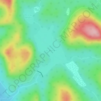
Name: Lac Beloeil topographic map, elevation, terrain.
Average elevation: 2,841 ft
Minimum elevation: 2,657 ft
Maximum elevation: 3,238 ft
Make a donation
Gear up for your next adventure:
As an Amazon Associate, this site earns from qualifying purchases at no extra cost to you.
Other topographic maps
Click on a map to view its topography, its elevation and its terrain.
Make a donation
Gear up for your next adventure:
As an Amazon Associate, this site earns from qualifying purchases at no extra cost to you.
Mont du Lac des Cygnes
Canada > Québec > Charlevoix > Lac-Pikauba
Le mont du Lac des Cygnes est une montagne du massif du Lac Jacques-Cartier (chaîne des Laurentides) située au sein du parc national des Grands-Jardins. Son sommet culminant à 980 m d'altitude et qui surplombe la vallée de la rivière du Gouffre est l'une des principales attractions du parc.
Average elevation: 2,198 ft
Make a donation
Gear up for your next adventure:
As an Amazon Associate, this site earns from qualifying purchases at no extra cost to you.