
Make a donation
Gear up for your next adventure:
As an Amazon Associate, this site earns from qualifying purchases at no extra cost to you.
Valenzuela topographic map
Click on the map to display elevation.
Make a donation
Gear up for your next adventure:
As an Amazon Associate, this site earns from qualifying purchases at no extra cost to you.
Valenzuela
Valenzuela is a municipality in the province of Córdoba, Spain. In 2016 it had 1208 inhabitants. Its surface area is 19 km² and has a density of 63.58 inhabitants / km². It is located at an altitude of 341 meters above sea level and 84 kilometers from the capital of the province, Córdoba.
Make a donation
Gear up for your next adventure:
As an Amazon Associate, this site earns from qualifying purchases at no extra cost to you.
About this map
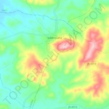
Name: Valenzuela topographic map, elevation, terrain.
Location: Valenzuela, Córdoba, Andalusia, Spain (37.73850 -4.27931 37.79406 -4.20658)
Average elevation: 1,096 ft
Minimum elevation: 846 ft
Maximum elevation: 1,575 ft
Make a donation
Gear up for your next adventure:
As an Amazon Associate, this site earns from qualifying purchases at no extra cost to you.
Other topographic maps
Click on a map to view its topography, its elevation and its terrain.
Gabia Grande
Spain > Andalusia > Comarca de la Vega de Granada > Las Gabias
Average elevation: 2,280 ft
Mijas
Spain > Andalusia > Costa del Sol Occidental > Mijas > Mijas
The climate changes gradually with increasing elevation in the mountains. Temperatures can drop to 10 °C (50 °F). In the peaks, over 600 m (2,000 ft) high, some ice may form in winter, while precipitation increases to almost 800 mm (32 in).
Average elevation: 1,467 ft
Park Beach
Spain > Andalusia > Costa del Sol Occidental > Estepona > Park Beach
Average elevation: 43 ft
Make a donation
Gear up for your next adventure:
As an Amazon Associate, this site earns from qualifying purchases at no extra cost to you.