
Rans topographic map
Interactive map
Click on the map to display elevation.
About this map
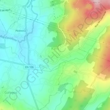
Name: Rans topographic map, elevation, terrain.
Location: Rans, Penafiel, Porto, 4560-755, Portugal (41.16036 -8.31393 41.17915 -8.27730)
Average elevation: 837 ft
Minimum elevation: 564 ft
Maximum elevation: 1,434 ft
Other topographic maps
Click on a map to view its topography, its elevation and its terrain.
Recezinhos (São Martinho)
Recezinhos (São Martinho), Penafiel, Porto, 4560-807, Portugal
Average elevation: 1,066 ft
Rio de Moinhos
Rio de Moinhos, Penafiel, Porto, Portugal
Average elevation: 646 ft
Alto do Marco
Portugal > Porto > Penafiel > Capela
Alto do Marco, Capela, Penafiel, Porto, 4560-192, Portugal
Average elevation: 869 ft