
Make a donation
Gear up for your next adventure:
As an Amazon Associate, this site earns from qualifying purchases at no extra cost to you.
Oppenweiler topographic map
Click on the map to display elevation.
Make a donation
Gear up for your next adventure:
As an Amazon Associate, this site earns from qualifying purchases at no extra cost to you.
Oppenweiler
Zur Gemeinde Oppenweiler gehören neben den nahegelegenen Ortsteilen Reichenberg, Ellenweiler, Rüflensmühle, Reichenbach, Aichelbach, Zell, Rohrbach, Schiffrain, Wilhelmsheim, Unterstaigacker auch das abgelegene Bernhalden im Lautertal. Der ehemalige Ortsteil Dauernberg, auf dem Höhenzug jenseits des Lautertals gelegen, wurde 1977 im Zuge der Gemeindereform nach Spiegelberg umgegliedert. Im 19. Jahrhundert gab es noch eine zugehörige Einzelsiedlung Charlottenhof nordwestlich auf der so genannten Charlottenhöhe über dem namengebenden Ort, der aber seit Mitte des 19. Jahrhunderts wüst liegt.
Make a donation
Gear up for your next adventure:
As an Amazon Associate, this site earns from qualifying purchases at no extra cost to you.
About this map
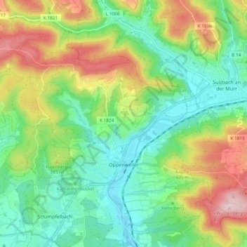
Name: Oppenweiler topographic map, elevation, terrain.
Average elevation: 1,168 ft
Minimum elevation: 823 ft
Maximum elevation: 1,781 ft
Make a donation
Gear up for your next adventure:
As an Amazon Associate, this site earns from qualifying purchases at no extra cost to you.
Other topographic maps
Click on a map to view its topography, its elevation and its terrain.
Kirchenkirnberg
Deutschland > Baden-Württemberg > Rems-Murr-Kreis > Murrhardt
Average elevation: 1,575 ft
Stöckenhof
Deutschland > Baden-Württemberg > Rems-Murr-Kreis > Berglen > Öschelbronn
Average elevation: 1,188 ft
Make a donation
Gear up for your next adventure:
As an Amazon Associate, this site earns from qualifying purchases at no extra cost to you.
Make a donation
Gear up for your next adventure:
As an Amazon Associate, this site earns from qualifying purchases at no extra cost to you.
Hertmannsweiler
Deutschland > Baden-Württemberg > Rems-Murr-Kreis > Winnenden > Hertmannsweiler
Average elevation: 1,079 ft
Vordersteinenberg
Deutschland > Baden-Württemberg > Rems-Murr-Kreis > Alfdorf > Vordersteinenberg
Average elevation: 1,604 ft
Zwingelhausen
Deutschland > Baden-Württemberg > Rems-Murr-Kreis > Kirchberg an der Murr
Average elevation: 991 ft
Make a donation
Gear up for your next adventure:
As an Amazon Associate, this site earns from qualifying purchases at no extra cost to you.