
Thank you for supporting this site ❤️
Make a donation
Make a donation
Gear up for your next adventure:
As an Amazon Associate, this site earns from qualifying purchases at no extra cost to you.
Vito d'Asio topographic map
Click on the map to display elevation.
Thank you for supporting this site ❤️
Make a donation
Make a donation
Gear up for your next adventure:
As an Amazon Associate, this site earns from qualifying purchases at no extra cost to you.
About this map
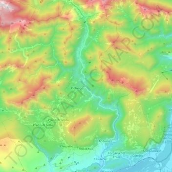
Name: Vito d'Asio topographic map, elevation, terrain.
Location: Vito d'Asio, Pordenone, Friuli-Venezia Giulia, Italy (46.20911 12.90183 46.34702 12.99070)
Average elevation: 2,398 ft
Minimum elevation: 449 ft
Maximum elevation: 6,129 ft
Thank you for supporting this site ❤️
Make a donation
Make a donation
Gear up for your next adventure:
As an Amazon Associate, this site earns from qualifying purchases at no extra cost to you.
Other topographic maps
Click on a map to view its topography, its elevation and its terrain.
Vajont dam
Italy > Friuli-Venezia Giulia > Pordenone > Erto e Casso > Casso
Average elevation: 2,920 ft