
Make a donation
Gear up for your next adventure:
As an Amazon Associate, this site earns from qualifying purchases at no extra cost to you.
Castelos topographic map
Click on the map to display elevation.
Make a donation
Gear up for your next adventure:
As an Amazon Associate, this site earns from qualifying purchases at no extra cost to you.
About this map
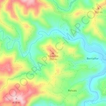
Name: Castelos topographic map, elevation, terrain.
Location: Castelos, Tavira, Faro, 8800-021, Portugal (37.30006 -7.77113 37.30016 -7.77103)
Average elevation: 827 ft
Minimum elevation: 492 ft
Maximum elevation: 1,316 ft
Make a donation
Gear up for your next adventure:
As an Amazon Associate, this site earns from qualifying purchases at no extra cost to you.
Other topographic maps
Click on a map to view its topography, its elevation and its terrain.
Santa Catarina
Portugal > Faro > Tavira > Santa Catarina da Fonte do Bispo > Várzeas
Average elevation: 551 ft
Make a donation
Gear up for your next adventure:
As an Amazon Associate, this site earns from qualifying purchases at no extra cost to you.
Make a donation
Gear up for your next adventure:
As an Amazon Associate, this site earns from qualifying purchases at no extra cost to you.