Geolocate

Oakley topographic map

Click on the map to display elevation.

About this map

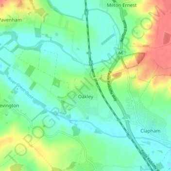
Name: Oakley topographic map, elevation, terrain.

Location: Oakley, Bedford, England, United Kingdom (52.16114 -0.56380 52.18631 -0.49633)

Average elevation: 161 ft

Minimum elevation: 95 ft

Maximum elevation: 295 ft

Other topographic maps

Click on a map to view its topography, its elevation and its terrain.

Bedford

United Kingdom > England > Bedford

As with the rest of the United Kingdom, Bedford has a maritime climate, with a limited range of temperatures, and generally even rainfall throughout the year. The nearest Met Office weather station to Bedford is Bedford (Thurleigh) airport, about 6.5 miles (10.5 km) north of Bedford town centre at an elevation…

Average elevation: 121 ft

Keysoe

United Kingdom > England > Bedford

Average elevation: 190 ft

Bolnhurst

United Kingdom > England > Bedford

Average elevation: 243 ft

Wilstead

United Kingdom > England > Bedford

Average elevation: 148 ft

Knotting

United Kingdom > England > Bedford

Average elevation: 289 ft

Box End

United Kingdom > England > Bedford

Average elevation: 141 ft

Rootham's Green

United Kingdom > England > Bedford

Average elevation: 213 ft

Church End

United Kingdom > England > Bedford > Ravensden

Average elevation: 190 ft

Little Wootton

United Kingdom > England > Bedford > Wootton

Average elevation: 171 ft

Wootton Green

United Kingdom > England > Bedford > Wootton

Average elevation: 157 ft

South Lagoon

United Kingdom > England > Bedford > Wyboston

Average elevation: 69 ft

Wyboston

United Kingdom > England > Bedford

Average elevation: 75 ft

Hinwick

United Kingdom > England > Bedford

Average elevation: 299 ft

Harrowden

United Kingdom > England > Bedford > Shortstown

Average elevation: 95 ft

Wood End

United Kingdom > England > Bedford

Average elevation: 167 ft

Radwell

United Kingdom > England > Bedford

Average elevation: 174 ft

Cross End

United Kingdom > England > Bedford > Thurleigh

Average elevation: 249 ft

Hanson Reach

United Kingdom > England > Bedford > Stewartby

Average elevation: 131 ft

Ransom's Wood

United Kingdom > England > Bedford

Average elevation: 187 ft

Knotting Green

United Kingdom > England > Bedford

Average elevation: 279 ft

Old Warden Tunnel

United Kingdom > England > Bedford > Cardington

Average elevation: 200 ft

Souldrop

United Kingdom > England > Bedford

Average elevation: 292 ft

Carlton

United Kingdom > England > Bedford > Carlton

Average elevation: 203 ft

Gear up for your next adventure:

🛰️Satellite Messengers - Emergency SOS and two-way messaging for off-grid adventures
🔌USB Car Charger - Car charger for on‑the‑go power needs
❄️Traction Cleats - Prevent slips on icy trails during winter hikes
🏕️Tent Footprint - Protect your tent base from wear
⛑️Personal Locator Beacon - Safety beacon for emergencies

As an Amazon Associate, this site earns from qualifying purchases at no extra cost to you.