Geolocate

Cayran topographic map

Click on the map to display elevation.

About this map

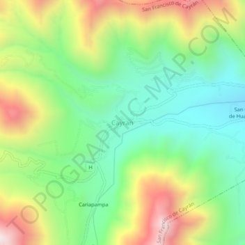
Name: Cayran topographic map, elevation, terrain.

Location: Cayran, San Francisco de Cayrán, Huánuco, 10061, Perú (-10.00094 -76.30403 -9.96094 -76.26403)

Average elevation: 8,015 ft

Minimum elevation: 6,745 ft

Maximum elevation: 10,072 ft

Gear up for your next adventure:

🥾Hiking Shoes - Durable and comfortable shoes for trail hiking
📻Weather Alert Radios - Stay informed of storm risks while off-the-grid
📷Action Camera - Capture your outdoor adventures in HD
🎒Day Hiking Backpack - Lightweight backpack perfect for day trips and outdoor adventures
🛰️Handheld GPS Units - Professional satellite navigators for precise backcountry mapping

As an Amazon Associate, this site earns from qualifying purchases at no extra cost to you.