
Pozo topographic map
Click on the map to display elevation.
About this map
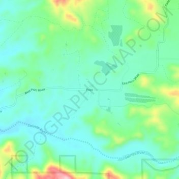
Name: Pozo topographic map, elevation, terrain.
Location: Pozo, San Luis Obispo County, California, United States (35.28368 -120.39623 35.32368 -120.35623)
Average elevation: 1,545 ft
Minimum elevation: 1,375 ft
Maximum elevation: 2,037 ft
San Luis Obispo County trails, hiking, mountain biking, running and outdoor activities
Other topographic maps
Click on a map to view its topography, its elevation and its terrain.
Cambria
United States > California > San Luis Obispo County > Cambria
Because lumber production, ranching activities and mercury mining increased in the area, the village adopted the more dignified name of Cambria. Locals seem to agree that the name was contributed by a local surveyor from Cambria County, Pennsylvania, because the local topography and flora reminded him of that…
Average elevation: 190 ft
Lake Nacimiento
United States > California > San Luis Obispo County > Heritage Ranch
Average elevation: 1,024 ft
Paso Robles
United States > California > San Luis Obispo County
The topography of the area consists of gentle rolling hills on the eastern half of the city, and foothill peaks, which rise in elevation to the Santa Lucia Coastal Range on the west, which are all blanketed in the Californian chaparral environment, which is mainly dry grassland and oak woodland. Paso Robles…
Average elevation: 974 ft
Laguna Hills Park
United States > California > San Luis Obispo County > San Luis Obispo
Average elevation: 269 ft
Cambria
United States > California > San Luis Obispo County
Originally an American settlement called Slab Town, the town later known as Cambria was centered at the Leffingwell cove of today's northern Moonstone Beach, which beach also featured a wharf. Because lumber production, ranching activities and mercury mining increased in the area, the village adopted the more…
Average elevation: 190 ft
Paso Robles
United States > California > San Luis Obispo County
The topography of the area consists of gentle rolling hills on the eastern half of the city, and foothill peaks, which rise in elevation to the Santa Lucia Coastal Range on the west, which are all blanketed in the Californian chaparral environment, which is mainly dry grassland and oak woodland. Paso Robles…
Average elevation: 974 ft
Guadalupe-Nipomo Dunes National Wildlife Refuge
United States > California > San Luis Obispo County
Average elevation: 69 ft
Pike Place
United States > California > San Luis Obispo County > Oceano > Halcyon
Average elevation: 82 ft