
Make a donation
Gear up for your next adventure:
As an Amazon Associate, this site earns from qualifying purchases at no extra cost to you.
Grigny topographic map
Click on the map to display elevation.
Make a donation
Gear up for your next adventure:
As an Amazon Associate, this site earns from qualifying purchases at no extra cost to you.
Grigny
La ville de Grigny est située au sud de Lyon à environ 17 km. Elle se situe à une altitude moyenne de 160 mètres environ. L'altitude minimum et maximum étant respectivement 152 m et 245 m. Géographiquement la latitude de Grigny est de 45.611 degrés Nord et sa longitude de 4.793 degrés Est.
Make a donation
Gear up for your next adventure:
As an Amazon Associate, this site earns from qualifying purchases at no extra cost to you.
About this map
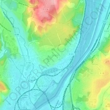
Name: Grigny topographic map, elevation, terrain.
Average elevation: 630 ft
Minimum elevation: 495 ft
Maximum elevation: 971 ft
Make a donation
Gear up for your next adventure:
As an Amazon Associate, this site earns from qualifying purchases at no extra cost to you.