Geolocate

Caltrano topographic map

Click on the map to display elevation.

About this map

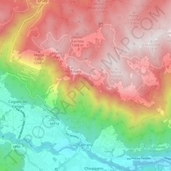
Name: Caltrano topographic map, elevation, terrain.

Location: Caltrano, Vicenza, Veneto, Italia (45.76126 11.43631 45.82243 11.50333)

Average elevation: 2,776 ft

Minimum elevation: 541 ft

Maximum elevation: 4,941 ft

Gear up for your next adventure:

🔭Compact Binoculars - HD vision for scouting terrain and identifying distant landmarks
🥘Titanium Cookware - Durable, featherlight pots and pans for backpacking
🎒Trail Energy Bars - High‑calorie bars for hiking energy
📷Action Camera - Capture your outdoor adventures in HD
🌄Hiking Binoculars - Compact binoculars for scenic views and trail spotting

As an Amazon Associate, this site earns from qualifying purchases at no extra cost to you.