
Bertoua II topographic map
Interactive map
Click on the map to display elevation.
About this map
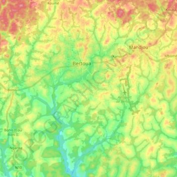
Name: Bertoua II topographic map, elevation, terrain.
Average elevation: 2,162 ft
Minimum elevation: 2,021 ft
Maximum elevation: 2,346 ft
Other topographic maps
Click on a map to view its topography, its elevation and its terrain.
Bertoua
Cameroun > Est > Lom-et-Djérem > Bertoua
Bertoua, Communauté urbaine de Bertoua, Lom-et-Djérem, Est, 707 BERTOUA, Cameroun
Average elevation: 2,221 ft
Mandjou
Cameroun > Est > Lom-et-Djérem > Mandjou
Mandjou, Lom-et-Djérem, Est, Cameroun
Average elevation: 2,195 ft
Ngamboula
Cameroun > Est > Lom-et-Djérem > Ngamboula
Ngamboula, Lom-et-Djérem, Est, Cameroun
Average elevation: 2,221 ft