
Make a donation
Gear up for your next adventure:
As an Amazon Associate, this site earns from qualifying purchases at no extra cost to you.
Panker topographic map
Click on the map to display elevation.
Make a donation
Gear up for your next adventure:
As an Amazon Associate, this site earns from qualifying purchases at no extra cost to you.
About this map
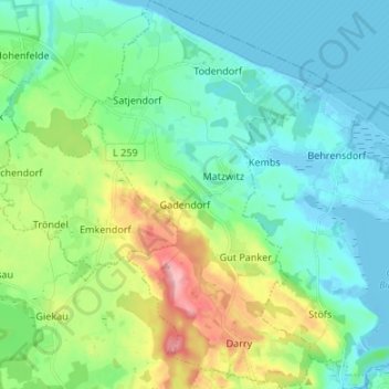
Name: Panker topographic map, elevation, terrain.
Average elevation: 108 ft
Minimum elevation: -23 ft
Maximum elevation: 427 ft
Make a donation
Gear up for your next adventure:
As an Amazon Associate, this site earns from qualifying purchases at no extra cost to you.
Other topographic maps
Click on a map to view its topography, its elevation and its terrain.
Make a donation
Gear up for your next adventure:
As an Amazon Associate, this site earns from qualifying purchases at no extra cost to you.
Make a donation
Gear up for your next adventure:
As an Amazon Associate, this site earns from qualifying purchases at no extra cost to you.
Rixdorf
Deutschland > Schleswig-Holstein > Kreis Plön
Ein kultureller Höhepunkt in Rixdorf war die Maifeier am 1. Mai eines jeden Jahres. Es trafen sich ab den Morgenstunden zahlreiche Musiker der Folk-Szene aus Schleswig-Holstein, Hamburg und den Niederlanden mit teilweise historischen (Bordun-) und anderen Folk-Instrumenten, um nach dem Aufstellen des Maibaums…
Average elevation: 141 ft
Heidkate
Deutschland > Schleswig-Holstein > Kreis Plön > Wisch
Marquardts erste Aufgabe war es, Siedler ins Land zu holen, so genannte Kolonisten. Er selbst legte sein Gehöft auf einer Anhöhe in den Salzwiesen an, und so ist die heute noch bestehende Hufe von Fernwisch – etwa einen Kilometer südlich von Heidkate – möglicherweise der Ausgangspunkt für die…
Average elevation: -3 ft
Schönberger Strand
Deutschland > Schleswig-Holstein > Kreis Plön > Schönberg (Holstein)
Average elevation: 3 ft
Make a donation
Gear up for your next adventure:
As an Amazon Associate, this site earns from qualifying purchases at no extra cost to you.
Ostseeküste zwischen Stakendorfer Strand und Hohenfelde und Umgebung
Deutschland > Schleswig-Holstein > Kreis Plön > Schwartbuck
Average elevation: 43 ft