
Murray County topographic map
Interactive map
Click on the map to display elevation.
About this map
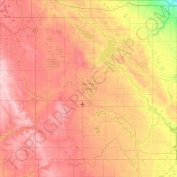
Name: Murray County topographic map, elevation, terrain.
Location: Murray County, Minnesota, United States (43.84790 -96.06532 44.19658 -95.46203)
Average elevation: 1,591 ft
Minimum elevation: 1,171 ft
Maximum elevation: 1,913 ft
The county terrain consists of low rolling hills, dotted with lakes and ponds, with all available area devoted to agriculture. The terrain slopes to the south and east. However, its highest elevation occurs on Buffalo Ridge, a promontory extending about two miles along the crest of the Coteau des Prairies in central Chanarambie Township. The bluff rises a few hundred feet above the adjacent valleys. The county has a total area of 720 square miles (1,900 km2), of which 705 square miles (1,830 km2) is land and 15 square miles (39 km2) (2.1%) is water.
Other topographic maps
Click on a map to view its topography, its elevation and its terrain.
Minneapolis
United States > Minnesota > Hennepin County
Minneapolis, Hennepin County, Minnesota, United States
Average elevation: 886 ft
Minneapolis
United States > Minnesota > Hennepin County > Minneapolis
Minneapolis, Hennepin County, Minnesota, 55488, United States
Average elevation: 889 ft
Saint Paul
United States > Minnesota > Ramsey County
Saint Paul, Ramsey County, Minnesota, United States
Average elevation: 879 ft
Duluth
United States > Minnesota > Saint Louis County
Duluth, Saint Louis County, Minnesota, United States
Average elevation: 938 ft
Bloomington
United States > Minnesota > Hennepin County
Bloomington, Hennepin County, Minnesota, United States
Average elevation: 837 ft
Rochester
United States > Minnesota > Olmsted County
Rochester, Olmsted County, Minnesota, United States
Average elevation: 1,161 ft
Olmsted County
Olmsted County, Minnesota, United States
Average elevation: 1,161 ft
Mankato
United States > Minnesota > Blue Earth County
Mankato, Blue Earth County, Minnesota, 56001, United States
Average elevation: 935 ft
Maple Grove
United States > Minnesota > Hennepin County
Maple Grove, Hennepin County, Minnesota, United States
Average elevation: 912 ft
Crow Wing County
Crow Wing County, Minnesota, United States
Average elevation: 1,266 ft
Hills
United States > Minnesota > Rock County
Hills, Martin Township, Rock County, Minnesota, 56138, United States
Average elevation: 1,460 ft
Kittson County
Kittson County, Minnesota, United States
Average elevation: 902 ft
Green Lake
United States > Minnesota > Beltrami County > Little Rock
Green Lake, Little Rock, Beltrami County, Minnesota, United States
Average elevation: 1,243 ft
Grey Cloud Island
United States > Minnesota > Washington County > Grey Cloud Island Township
Grey Cloud Island, Grey Cloud Island Township, Washington County, Minnesota, 55071, United States
Average elevation: 738 ft
West St. Paul
United States > Minnesota > Dakota County
West St. Paul, Dakota County, Minnesota, 55118, United States
Average elevation: 965 ft
Eagan
United States > Minnesota > Dakota County
Eagan, Dakota County, Minnesota, United States
Average elevation: 876 ft
Itasca County
Itasca County, Minnesota, United States
Average elevation: 1,352 ft
Dunnell
United States > Minnesota > Martin County
Dunnell, Martin County, Minnesota, United States
Average elevation: 1,322 ft
Gainy Park
United States > Minnesota > Steele County > Owatonna
Gainy Park, Owatonna, Steele County, Minnesota, United States
Average elevation: 1,178 ft
Glendale
United States > Minnesota > Scott County > Savage
Glendale, Savage, Scott County, Minnesota, 55378, United States
Average elevation: 860 ft
Big Deep Lake
United States > Minnesota > Cass County
Big Deep Lake, Cass County, Minnesota, United States
Average elevation: 1,378 ft
Oxlip
United States > Minnesota > Isanti County
Oxlip, Bradford Township, Isanti County, Minnesota, United States
Average elevation: 945 ft
Crown
United States > Minnesota > Isanti County
Crown, Stanford Township, Isanti County, Minnesota, United States
Average elevation: 968 ft
Weber
United States > Minnesota > Isanti County
Weber, North Branch Township, Isanti County, Minnesota, United States
Average elevation: 925 ft
Walbo
United States > Minnesota > Isanti County
Walbo, Springvale Township, Isanti County, Minnesota, United States
Average elevation: 938 ft
Springvale
United States > Minnesota > Isanti County
Springvale, Springvale Township, Isanti County, Minnesota, United States
Average elevation: 945 ft
Pine Brook
United States > Minnesota > Isanti County
Pine Brook, Springvale Township, Isanti County, Minnesota, United States
Average elevation: 955 ft
Grandy
United States > Minnesota > Isanti County
Grandy, Cambridge Township, Isanti County, Minnesota, 55029, United States
Average elevation: 935 ft
Elm Park
United States > Minnesota > Isanti County
Elm Park, Maple Ridge Township, Isanti County, Minnesota, United States
Average elevation: 951 ft
Stanchfield
United States > Minnesota > Isanti County
Stanchfield, Stanchfield Township, Isanti County, Minnesota, 55080, United States
Average elevation: 942 ft
Bodum
United States > Minnesota > Isanti County
Bodum, Isanti Township, Isanti County, Minnesota, 55008, United States
Average elevation: 965 ft
Wyanett
United States > Minnesota > Isanti County
Wyanett, Wyanett Township, Isanti County, Minnesota, United States
Average elevation: 961 ft
West Point
United States > Minnesota > Isanti County
West Point, Spencer Brook Township, Isanti County, Minnesota, United States
Average elevation: 942 ft
Stanley
United States > Minnesota > Isanti County
Stanley, Isanti Township, Isanti County, Minnesota, United States
Average elevation: 961 ft
Stanchfield Corner
United States > Minnesota > Isanti County
Stanchfield Corner, Stanchfield Township, Isanti County, Minnesota, 55080, United States
Average elevation: 942 ft
Spring Lake
United States > Minnesota > Isanti County
Spring Lake, North Branch Township, Isanti County, Minnesota, United States
Average elevation: 938 ft
Spencer Brook
United States > Minnesota > Isanti County
Spencer Brook, Spencer Brook Township, Isanti County, Minnesota, United States
Average elevation: 948 ft
Edgewood
United States > Minnesota > Isanti County
Edgewood, Isanti Township, Isanti County, Minnesota, 55008, United States
Average elevation: 948 ft
Day
United States > Minnesota > Isanti County
Day, Maple Ridge Township, Isanti County, Minnesota, United States
Average elevation: 991 ft
Dalbo
United States > Minnesota > Isanti County
Dalbo, Dalbo Township, Isanti County, Minnesota, 55017, United States
Average elevation: 971 ft
Carmody
United States > Minnesota > Isanti County
Carmody, Dalbo Township, Isanti County, Minnesota, 55017, United States
Average elevation: 981 ft
Blomford
United States > Minnesota > Isanti County
Blomford, Isanti Township, Isanti County, Minnesota, United States
Average elevation: 951 ft
Andree
United States > Minnesota > Isanti County
Andree, Stanchfield Township, Isanti County, Minnesota, 55006, United States
Average elevation: 955 ft
Isanti
United States > Minnesota > Isanti County
Isanti, Isanti County, Minnesota, United States
Average elevation: 935 ft
Shorewood
United States > Minnesota > Hennepin County
Shorewood, Tonka Bay, Hennepin County, Minnesota, 55331, United States
Average elevation: 961 ft
Bradford
United States > Minnesota > Isanti County
Bradford, Bradford Township, Isanti County, Minnesota, United States
Average elevation: 942 ft
Athens
United States > Minnesota > Isanti County
Athens, Athens Township, Isanti County, Minnesota, 55040, United States
Average elevation: 932 ft
Cook County
Cook County, Minnesota, United States
Average elevation: 1,260 ft
Wayzata
United States > Minnesota > Hennepin County
Wayzata, Hennepin County, Minnesota, United States
Average elevation: 955 ft
Sherburne County
Sherburne County, Minnesota, United States
Average elevation: 978 ft