Geolocate

Isanti topographic map

Click on the map to display elevation.

About this map

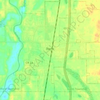
Name: Isanti topographic map, elevation, terrain.

Location: Isanti, Isanti County, Minnesota, United States (45.46767 -93.27075 45.51173 -93.20914)

Average elevation: 935 ft

Minimum elevation: 889 ft

Maximum elevation: 968 ft

Isanti County trails, hiking, mountain biking, running and outdoor activities

Other topographic maps

Click on a map to view its topography, its elevation and its terrain.

Dalbo

United States > Minnesota > Isanti County

Average elevation: 971 ft

Bradford

United States > Minnesota > Isanti County

Average elevation: 942 ft

Stanchfield

United States > Minnesota > Isanti County

Average elevation: 942 ft

Andree

United States > Minnesota > Isanti County

Average elevation: 955 ft

Athens

United States > Minnesota > Isanti County

Average elevation: 932 ft

Blomford

United States > Minnesota > Isanti County

Average elevation: 951 ft

Carmody

United States > Minnesota > Isanti County

Average elevation: 981 ft

Crown

United States > Minnesota > Isanti County

Average elevation: 968 ft

Day

United States > Minnesota > Isanti County

Average elevation: 991 ft

Edgewood

United States > Minnesota > Isanti County

Average elevation: 948 ft

Elm Park

United States > Minnesota > Isanti County

Average elevation: 951 ft

Grandy

United States > Minnesota > Isanti County

Average elevation: 935 ft

Oxlip

United States > Minnesota > Isanti County

Average elevation: 945 ft

Pine Brook

United States > Minnesota > Isanti County

Average elevation: 955 ft

Spencer Brook

United States > Minnesota > Isanti County

Average elevation: 948 ft

Spring Lake

United States > Minnesota > Isanti County

Average elevation: 938 ft

Springvale

United States > Minnesota > Isanti County

Average elevation: 945 ft

Stanley

United States > Minnesota > Isanti County

Average elevation: 961 ft

Walbo

United States > Minnesota > Isanti County

Average elevation: 938 ft

Weber

United States > Minnesota > Isanti County

Average elevation: 925 ft

West Point

United States > Minnesota > Isanti County

Average elevation: 942 ft

Wyanett

United States > Minnesota > Isanti County

Average elevation: 961 ft

Bodum

United States > Minnesota > Isanti County

Average elevation: 965 ft

Cambridge

United States > Minnesota > Isanti County > Cambridge > Cambridge

Average elevation: 948 ft

Gear up for your next adventure:

🌡️Portable Weather Meter - Track weather conditions on the trail
Camping Coffee Makers - Enjoy premium coffee at the summit or campsite
👟Men's Trail Runners - Lightweight footwear for fast-paced exploration and light hiking
🗃️Trail First Aid Kit - Essential kit for outdoor injuries and emergencies
📖Nature Tracking Books - Learn to track wildlife and terrain

As an Amazon Associate, this site earns from qualifying purchases at no extra cost to you.