
Shorewood topographic map
Click on the map to display elevation.
About this map
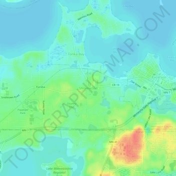
Name: Shorewood topographic map, elevation, terrain.
Average elevation: 961 ft
Minimum elevation: 919 ft
Maximum elevation: 1,083 ft
Hennepin County trails, hiking, mountain biking, running and outdoor activities
Other topographic maps
Click on a map to view its topography, its elevation and its terrain.
Stevens Square - Loring Heights
United States > Minnesota > Hennepin County > Minneapolis
Average elevation: 873 ft
North Commons Park
United States > Minnesota > Hennepin County > Minneapolis
Average elevation: 876 ft