
Thank you for supporting this site ❤️
Make a donation
Make a donation
Gear up for your next adventure:
As an Amazon Associate, this site earns from qualifying purchases at no extra cost to you.
Vesimo topographic map
Click on the map to display elevation.
Thank you for supporting this site ❤️
Make a donation
Make a donation
Gear up for your next adventure:
As an Amazon Associate, this site earns from qualifying purchases at no extra cost to you.
About this map
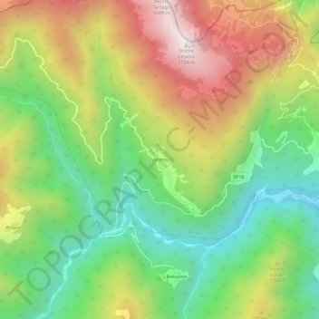
Name: Vesimo topographic map, elevation, terrain.
Location: Vesimo, Zerba, Piacenza, Emilia-Romagna, Italia (44.64535 9.23487 44.68535 9.27487)
Average elevation: 3,396 ft
Minimum elevation: 1,765 ft
Maximum elevation: 5,584 ft
Thank you for supporting this site ❤️
Make a donation
Make a donation
Gear up for your next adventure:
As an Amazon Associate, this site earns from qualifying purchases at no extra cost to you.