
Make a donation
Gear up for your next adventure:
As an Amazon Associate, this site earns from qualifying purchases at no extra cost to you.
Saint Louis topographic map
Click on the map to display elevation.
Make a donation
Gear up for your next adventure:
As an Amazon Associate, this site earns from qualifying purchases at no extra cost to you.
About this map
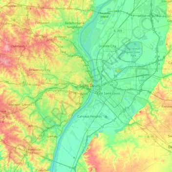
Name: Saint Louis topographic map, elevation, terrain.
Average elevation: 495 ft
Minimum elevation: 367 ft
Maximum elevation: 741 ft
Missouri trails, hiking, mountain biking, running and outdoor activities
Make a donation
Gear up for your next adventure:
As an Amazon Associate, this site earns from qualifying purchases at no extra cost to you.
Other topographic maps
Click on a map to view its topography, its elevation and its terrain.
Ellendale
United States > Missouri > Saint Louis > Ellendale
Originally, the River des Peres ran through the neighborhood, from its underground beginnings in Forest Park. It was converted to a drainage project, and now all that remains is the valley created by it. This valley forms the main topographical characteristic of the neighborhood.
Average elevation: 495 ft
Make a donation
Gear up for your next adventure:
As an Amazon Associate, this site earns from qualifying purchases at no extra cost to you.