
Thank you for supporting this site ❤️
Make a donation
Make a donation
Gear up for your next adventure:
As an Amazon Associate, this site earns from qualifying purchases at no extra cost to you.
Sunday Island topographic map
Click on the map to display elevation.
Thank you for supporting this site ❤️
Make a donation
Make a donation
Gear up for your next adventure:
As an Amazon Associate, this site earns from qualifying purchases at no extra cost to you.
About this map
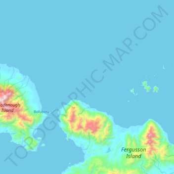
Name: Sunday Island topographic map, elevation, terrain.
Location: Sunday Island, Milne Bay, Southern Region, Papua New Guinea (-9.60333 150.21333 -8.96333 150.85333)
Average elevation: 390 ft
Minimum elevation: -3 ft
Maximum elevation: 7,323 ft
Thank you for supporting this site ❤️
Make a donation
Make a donation
Gear up for your next adventure:
As an Amazon Associate, this site earns from qualifying purchases at no extra cost to you.