Geolocate

Etty topographic map

Click on the map to display elevation.

About this map

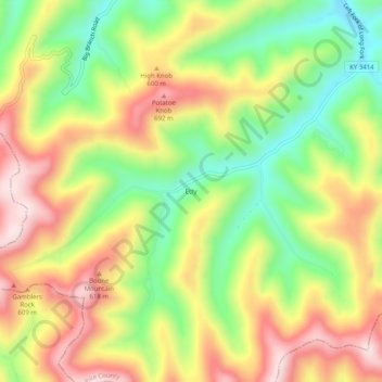
Name: Etty topographic map, elevation, terrain.

Location: Etty, Pike County, Kentucky, 41835, United States (37.23233 -82.69710 37.27233 -82.65710)

Average elevation: 1,683 ft

Minimum elevation: 1,076 ft

Maximum elevation: 2,316 ft

Pike County trails, hiking, mountain biking, running and outdoor activities

Other topographic maps

Click on a map to view its topography, its elevation and its terrain.

Pikeville

United States > Kentucky > Pike County

Average elevation: 1,109 ft

Crow Hollow

United States > Kentucky > Pike County > Douglas

Average elevation: 1,142 ft

Gear up for your next adventure:

Camping Coffee Makers - Enjoy premium coffee at the summit or campsite
🌡️Portable Weather Meter - Track weather conditions on the trail
🪑Portable Camp Table - Compact table for campsite meals
🧥Men's Rain Shells - Premium waterproof and breathable jackets for mountain weather
📱Solar Portable Charger - Solar power bank for charging devices off‑grid

As an Amazon Associate, this site earns from qualifying purchases at no extra cost to you.