
Thank you for supporting this site ❤️
Make a donation
Make a donation
Gear up for your next adventure:
As an Amazon Associate, this site earns from qualifying purchases at no extra cost to you.
Heimgarten topographic map
Click on the map to display elevation.
Thank you for supporting this site ❤️
Make a donation
Make a donation
Gear up for your next adventure:
As an Amazon Associate, this site earns from qualifying purchases at no extra cost to you.
Heimgarten
Heimgarten (elevation 1,790 metres/5,870 ft) is a mountain near Ohlstadt in the Bavarian Prealps of southern Germany. It is connected via a ridge with Herzogstand (1,731 metres/5,679 ft) to the east.
Thank you for supporting this site ❤️
Make a donation
Make a donation
Gear up for your next adventure:
As an Amazon Associate, this site earns from qualifying purchases at no extra cost to you.
About this map
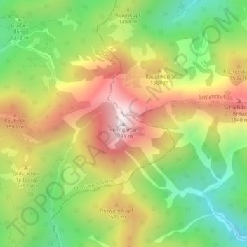
Name: Heimgarten topographic map, elevation, terrain.
Average elevation: 4,403 ft
Minimum elevation: 3,169 ft
Maximum elevation: 5,807 ft
Thank you for supporting this site ❤️
Make a donation
Make a donation
Gear up for your next adventure:
As an Amazon Associate, this site earns from qualifying purchases at no extra cost to you.