Geolocate

Wileyville topographic map

Click on the map to display elevation.

About this map

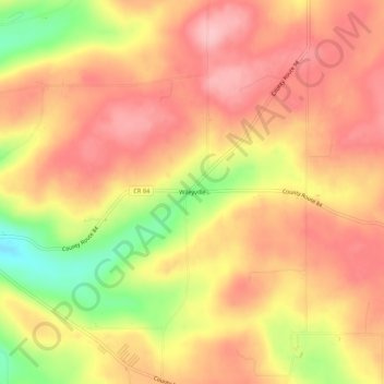
Name: Wileyville topographic map, elevation, terrain.

Location: Wileyville, Town of West Union, Steuben County, New York, United States (42.00757 -77.71666 42.04757 -77.67666)

Average elevation: 2,208 ft

Minimum elevation: 1,893 ft

Maximum elevation: 2,379 ft

Steuben County trails, hiking, mountain biking, running and outdoor activities

Other topographic maps

Click on a map to view its topography, its elevation and its terrain.

City of Corning

United States > New York > Steuben County

Average elevation: 1,102 ft

Town of Bradford

United States > New York > Steuben County

Average elevation: 1,490 ft

Town of Lindley

United States > New York > Steuben County

Average elevation: 1,411 ft

Town of Cameron

United States > New York > Steuben County

Average elevation: 1,644 ft

Painted Post

United States > New York > Steuben County

Average elevation: 1,076 ft

City of Hornell

United States > New York > Steuben County

Hornell is located at 42°19′N 77°40′W / 42.317°N 77.667°W / 42.317; -77.667 (42.3244, -77.6603). Hornell is at an altitude of 1,160 feet (350 meters) above sea level.

Average elevation: 1,512 ft

Town of Campbell

United States > New York > Steuben County

Average elevation: 1,381 ft

Village of Wayland

United States > New York > Steuben County

Average elevation: 1,394 ft

Town of Prattsburgh

United States > New York > Steuben County

The town is at a higher altitude than most other parts of the county.

Average elevation: 1,696 ft

Village of Bath

United States > New York > Steuben County

Average elevation: 1,217 ft

Town of Bath

United States > New York > Steuben County

Average elevation: 1,476 ft

Town of Wayne

United States > New York > Steuben County

Average elevation: 1,211 ft

Village of Hammondsport

United States > New York > Steuben County

Beginning in 1894 Hammondsport received its first water system from springs that were contained in the Rufus Scofield farm, on Mt. Washington, not far from the village. Aside from supplying the village with pure spring water, one of the first objectives was to install five fire hydrants at convenient locations…

Average elevation: 945 ft

Town of Urbana

United States > New York > Steuben County

Average elevation: 1,316 ft

Town of Cohocton

United States > New York > Steuben County

Average elevation: 1,663 ft

City of Corning

United States > New York > Steuben County

Average elevation: 1,102 ft

Town of Jasper

United States > New York > Steuben County

Average elevation: 1,873 ft

Town of Hartsville

United States > New York > Steuben County

Average elevation: 1,985 ft

Town of Woodhull

United States > New York > Steuben County

Average elevation: 1,647 ft

Town of Rathbone

United States > New York > Steuben County

Average elevation: 1,463 ft

Town of Hornby

United States > New York > Steuben County

Average elevation: 1,627 ft

Town of Corning

United States > New York > Steuben County

Average elevation: 1,355 ft

Town of Lindley

United States > New York > Steuben County

Average elevation: 1,411 ft

Village of Addison

United States > New York > Steuben County

Average elevation: 1,224 ft

Canisteo

United States > New York > Steuben County > Canisteo

Average elevation: 1,283 ft

Gear up for your next adventure:

🔥Camping Stove - Portable stove for camping and backcountry cooking
🧭GPS Watch Accessories - Bands and chargers for GPS watches
🪑Ultralight Camp Chairs - Portable seating for resting after a long day of mapping
🎒Gear Packing Cubes - Organize your backpack efficiently
📶Satellite Messenger - Communication device off‑grid

As an Amazon Associate, this site earns from qualifying purchases at no extra cost to you.