
Spring Hill topographic map
Click on the map to display elevation.
About this map
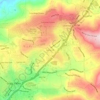
Name: Spring Hill topographic map, elevation, terrain.
Average elevation: 2,648 ft
Minimum elevation: 2,123 ft
Maximum elevation: 3,068 ft
Nevada County trails, hiking, mountain biking, running and outdoor activities
Other topographic maps
Click on a map to view its topography, its elevation and its terrain.
Empire Mine State Historic Park
United States > California > Nevada County > Grass Valley > Boston Ravine
Average elevation: 2,608 ft
Nevada County Fairgrounds
United States > California > Nevada County > Grass Valley > Boston Ravine
Average elevation: 2,438 ft