Geolocate

Antwerp topographic map

Click on the map to display elevation.

About this map

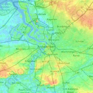
Name: Antwerp topographic map, elevation, terrain.

Location: Antwerp, Flanders, 2000, Belgium (51.06111 4.23971 51.38111 4.55971)

Average elevation: 30 ft

Minimum elevation: -16 ft

Maximum elevation: 125 ft

Other topographic maps

Click on a map to view its topography, its elevation and its terrain.

Borgerhout

Belgium > Antwerp > Antwerp > Antwerp

Average elevation: 26 ft

Gear up for your next adventure:

🔦Powerful Headlamps - Ultra-bright hands-free lighting for night navigation
💧Water Purification System - Clean water on the trail with reliable purifiers
GPS Sports Watch - GPS watch for running, hiking and training
🧺Microfiber Travel Towels - Compact and fast-drying towels for trail use
📦Dry Bags Set - Waterproof storage for electronics and clothes

As an Amazon Associate, this site earns from qualifying purchases at no extra cost to you.