Geolocate

Beuerberg topographic map

Click on the map to display elevation.

About this map

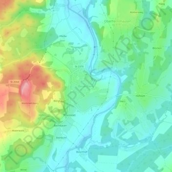
Name: Beuerberg topographic map, elevation, terrain.

Location: Beuerberg, Eurasburg, Landkreis Bad Tölz-Wolfratshausen, Bavaria, 82547, Germany (47.80612 11.39211 47.84612 11.43211)

Average elevation: 2,028 ft

Minimum elevation: 1,893 ft

Maximum elevation: 2,346 ft

Other topographic maps

Click on a map to view its topography, its elevation and its terrain.

Icking

Germany > Bavaria > Landkreis Bad Tölz-Wolfratshausen

Average elevation: 2,083 ft

Egling

Germany > Bavaria > Landkreis Bad Tölz-Wolfratshausen > Egling

Average elevation: 2,142 ft

Gear up for your next adventure:

🪶Fire Starter Kit - Reliable fire starter for survival and camping
🧥Waterproof Jacket for Hiking - Breathable and rugged rain jacket for outdoor excursions
🔭Compact Binoculars - HD vision for scouting terrain and identifying distant landmarks
🎒Gear Packing Cubes - Organize your backpack efficiently
🎒Trekking Poles - Sturdy poles for balance and stability on rough terrain

As an Amazon Associate, this site earns from qualifying purchases at no extra cost to you.