
Thank you for supporting this site ❤️
Make a donation
Make a donation
Gear up for your next adventure:
As an Amazon Associate, this site earns from qualifying purchases at no extra cost to you.
Müncheberg topographic map
Click on the map to display elevation.
Thank you for supporting this site ❤️
Make a donation
Make a donation
Gear up for your next adventure:
As an Amazon Associate, this site earns from qualifying purchases at no extra cost to you.
About this map
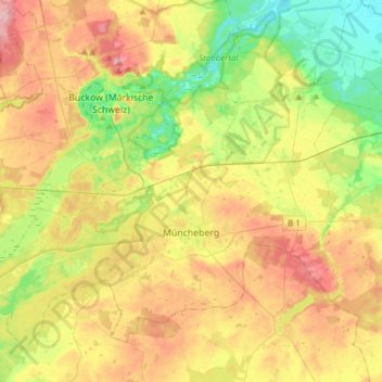
Name: Müncheberg topographic map, elevation, terrain.
Location: Müncheberg, Märkisch-Oderland, Brandenburg, 15374, Germany (52.44659 13.95297 52.60124 14.25852)
Average elevation: 200 ft
Minimum elevation: 16 ft
Maximum elevation: 420 ft
Thank you for supporting this site ❤️
Make a donation
Make a donation
Gear up for your next adventure:
As an Amazon Associate, this site earns from qualifying purchases at no extra cost to you.
Other topographic maps
Click on a map to view its topography, its elevation and its terrain.
Birkenstein
Germany > Brandenburg > Märkisch-Oderland > Hoppegarten > Dahlwitz-Hoppegarten
Average elevation: 180 ft