
Make a donation
Gear up for your next adventure:
As an Amazon Associate, this site earns from qualifying purchases at no extra cost to you.
Shanksville topographic map
Click on the map to display elevation.
Make a donation
Gear up for your next adventure:
As an Amazon Associate, this site earns from qualifying purchases at no extra cost to you.
Shanksville
Shanksville is located at 40°1′2″N 78°54′21″W / 40.01722°N 78.90583°W / 40.01722; -78.90583 (40.017182, -78.905891), with the borough covering 0.2 square mile (0.5 km2), all land; it also has the seventh-highest elevation of boroughs in Pennsylvania at 2,230 feet (680 m).
Make a donation
Gear up for your next adventure:
As an Amazon Associate, this site earns from qualifying purchases at no extra cost to you.
About this map
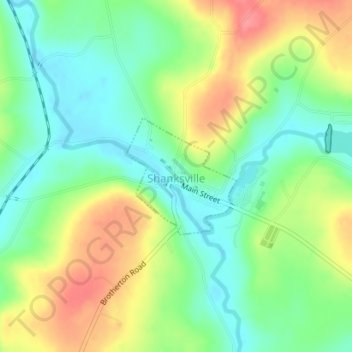
Name: Shanksville topographic map, elevation, terrain.
Average elevation: 2,303 ft
Minimum elevation: 2,198 ft
Maximum elevation: 2,457 ft
Somerset County trails, hiking, mountain biking, running and outdoor activities
Make a donation
Gear up for your next adventure:
As an Amazon Associate, this site earns from qualifying purchases at no extra cost to you.