
Watkinsville topographic map
Interactive map
Click on the map to display elevation.
About this map
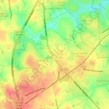
Name: Watkinsville topographic map, elevation, terrain.
Location: Watkinsville, Oconee County, Georgia, 30644, United States (33.84654 -83.42482 33.88104 -83.38777)
Average elevation: 715 ft
Minimum elevation: 600 ft
Maximum elevation: 797 ft
Other topographic maps
Click on a map to view its topography, its elevation and its terrain.
Bogart
United States > Georgia > Oconee County
Bogart, Oconee County, Georgia, United States
Average elevation: 801 ft
North High Shoals
United States > Georgia > Oconee County
North High Shoals, Oconee County, Georgia, United States
Average elevation: 702 ft