Geolocate

Bogart topographic map

Click on the map to display elevation.

About this map

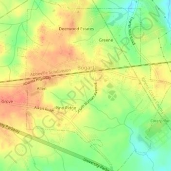
Name: Bogart topographic map, elevation, terrain.

Location: Bogart, Oconee County, Georgia, United States (33.93142 -83.54875 33.96081 -83.51678)

Average elevation: 801 ft

Minimum elevation: 712 ft

Maximum elevation: 863 ft

Oconee County trails, hiking, mountain biking, running and outdoor activities

Gear up for your next adventure:

🚗GPS Dash Cams - Record your scenic drives through mountain passes and canyons
🌄Hiking Binoculars - Compact binoculars for scenic views and trail spotting
🧥Waterproof Jacket for Hiking - Breathable and rugged rain jacket for outdoor excursions
🪶Compact Camp Shovel - Folding shovel for campsite tasks
📚USA Hiking Guide Books - Top trail guides and map books

As an Amazon Associate, this site earns from qualifying purchases at no extra cost to you.