
Make a donation
Gear up for your next adventure:
As an Amazon Associate, this site earns from qualifying purchases at no extra cost to you.
Upington topographic map
Click on the map to display elevation.
Make a donation
Gear up for your next adventure:
As an Amazon Associate, this site earns from qualifying purchases at no extra cost to you.
Upington
The elevation of Upington is 2,742 feet (835 metres). It is the closest large centre to the Augrabies Falls (arguably the greatest of South African waterfalls) and the Kgalagadi Transfrontier Park. The landscape is very arid but the soil is fertile and crops such as fruit are grown in irrigated fields. The area is best known for its export-quality grapes, raisins and wines, which are cultivated on the rich flood plains of the Orange River.
Make a donation
Gear up for your next adventure:
As an Amazon Associate, this site earns from qualifying purchases at no extra cost to you.
About this map
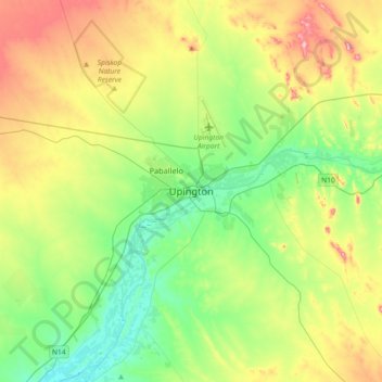
Name: Upington topographic map, elevation, terrain.
Average elevation: 2,785 ft
Minimum elevation: 2,510 ft
Maximum elevation: 3,301 ft
Make a donation
Gear up for your next adventure:
As an Amazon Associate, this site earns from qualifying purchases at no extra cost to you.
Other topographic maps
Click on a map to view its topography, its elevation and its terrain.
ǁKhara Hais Ward 11
South Africa > Northern Cape > ZF Mgcawu District Municipality > ǁKhara Hais Local Municipality
Average elevation: 3,005 ft
Mier Local Municipality
South Africa > Northern Cape > ZF Mgcawu District Municipality
Average elevation: 3,222 ft
Augrabies Falls National Park
South Africa > Northern Cape > ZF Mgcawu District Municipality
Average elevation: 2,402 ft
Lohatlha
South Africa > Northern Cape > ZF Mgcawu District Municipality > Tsantsabane Local Municipality
Average elevation: 4,508 ft
Make a donation
Gear up for your next adventure:
As an Amazon Associate, this site earns from qualifying purchases at no extra cost to you.
Kai !Garib Local Municipality
South Africa > Northern Cape > ZF Mgcawu District Municipality
Average elevation: 2,884 ft
Kanoneiland
South Africa > Northern Cape > ZF Mgcawu District Municipality > Kai !Garib Local Municipality
Average elevation: 2,556 ft
Tsantsabane Local Municipality
South Africa > Northern Cape > ZF Mgcawu District Municipality
Average elevation: 3,629 ft
Kgatelopele Local Municipality
South Africa > Northern Cape > ZF Mgcawu District Municipality
Average elevation: 4,787 ft
Make a donation
Gear up for your next adventure:
As an Amazon Associate, this site earns from qualifying purchases at no extra cost to you.
Kai !Garib Ward 7
South Africa > Northern Cape > ZF Mgcawu District Municipality > Kai !Garib Local Municipality
Average elevation: 2,638 ft
Kgatelopele Local Municipality
South Africa > Northern Cape > ZF Mgcawu District Municipality
Average elevation: 4,787 ft
Sout
South Africa > Northern Cape > ZF Mgcawu District Municipality > Kai !Garib Local Municipality
Average elevation: 2,789 ft
Klein Mier
South Africa > Northern Cape > ZF Mgcawu District Municipality > Mier Local Municipality
Average elevation: 2,766 ft
Make a donation
Gear up for your next adventure:
As an Amazon Associate, this site earns from qualifying purchases at no extra cost to you.
Tsantsabane Local Municipality
South Africa > Northern Cape > ZF Mgcawu District Municipality
Average elevation: 3,629 ft
Rietfontein
South Africa > Northern Cape > ZF Mgcawu District Municipality > Mier Local Municipality
Average elevation: 2,785 ft
Augrabies Falls National Park
South Africa > Northern Cape > ZF Mgcawu District Municipality
Average elevation: 2,402 ft