
Make a donation
Gear up for your next adventure:
As an Amazon Associate, this site earns from qualifying purchases at no extra cost to you.
Tsantsabane Local Municipality topographic map
Click on the map to display elevation.
Make a donation
Gear up for your next adventure:
As an Amazon Associate, this site earns from qualifying purchases at no extra cost to you.
About this map
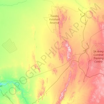
Name: Tsantsabane Local Municipality topographic map, elevation, terrain.
Average elevation: 3,629 ft
Minimum elevation: 2,615 ft
Maximum elevation: 5,958 ft
Make a donation
Gear up for your next adventure:
As an Amazon Associate, this site earns from qualifying purchases at no extra cost to you.
Other topographic maps
Click on a map to view its topography, its elevation and its terrain.
Upington
South Africa > Northern Cape > ZF Mgcawu District Municipality
The elevation of Upington is 2,742 feet (835 metres). It is the closest large centre to the Augrabies Falls (arguably the greatest of South African waterfalls) and the Kgalagadi Transfrontier Park. The landscape is very arid but the soil is fertile and crops such as fruit are grown in irrigated fields. The…
Average elevation: 2,785 ft
Kenhardt
South Africa > Northern Cape > ZF Mgcawu District Municipality > Kai !Garib Local Municipality
Average elevation: 2,651 ft
Postmasburg
South Africa > Northern Cape > ZF Mgcawu District Municipality > Tsantsabane Local Municipality
Average elevation: 4,354 ft
Daniëlskuil
South Africa > Northern Cape > ZF Mgcawu District Municipality > Kgatelopele Local Municipality
Average elevation: 4,852 ft
Make a donation
Gear up for your next adventure:
As an Amazon Associate, this site earns from qualifying purchases at no extra cost to you.
Lime Acres
South Africa > Northern Cape > ZF Mgcawu District Municipality > Kgatelopele Local Municipality
Average elevation: 4,908 ft
Groblershoop
South Africa > Northern Cape > ZF Mgcawu District Municipality > !Kheis Local Municipality
Average elevation: 2,900 ft
Kakamas
South Africa > Northern Cape > ZF Mgcawu District Municipality > Kai !Garib Local Municipality
Average elevation: 2,188 ft
Grootdrink
South Africa > Northern Cape > ZF Mgcawu District Municipality > !Kheis Local Municipality
Average elevation: 2,877 ft
Make a donation
Gear up for your next adventure:
As an Amazon Associate, this site earns from qualifying purchases at no extra cost to you.
Augrabies
South Africa > Northern Cape > ZF Mgcawu District Municipality > Kai !Garib Local Municipality
Average elevation: 2,152 ft
Upington
South Africa > Northern Cape > ZF Mgcawu District Municipality
The elevation of Upington is 2,742 feet (835 metres). It is the closest large centre to the Augrabies Falls (arguably the greatest of South African waterfalls) and the Kgalagadi Transfrontier Park. The landscape is very arid but the soil is fertile and crops such as fruit are grown in irrigated fields. The…
Average elevation: 2,785 ft
Groblershoop
South Africa > Northern Cape > ZF Mgcawu District Municipality > !Kheis Local Municipality
Average elevation: 2,900 ft
Lohatlha
South Africa > Northern Cape > ZF Mgcawu District Municipality > Tsantsabane Local Municipality
Average elevation: 4,508 ft
Make a donation
Gear up for your next adventure:
As an Amazon Associate, this site earns from qualifying purchases at no extra cost to you.
Upington
South Africa > Northern Cape > ZF Mgcawu District Municipality
The elevation of Upington is 2,742 feet (835 metres). It is the closest large centre to the Augrabies Falls (arguably the greatest of South African waterfalls) and the Kgalagadi Transfrontier Park. The landscape is very arid but the soil is fertile and crops such as fruit are grown in irrigated fields. The…
Average elevation: 2,785 ft
Kakamas
South Africa > Northern Cape > ZF Mgcawu District Municipality > Kai !Garib Local Municipality
Average elevation: 2,188 ft
Grootdrink
South Africa > Northern Cape > ZF Mgcawu District Municipality > !Kheis Local Municipality
Average elevation: 2,877 ft
Kanoneiland
South Africa > Northern Cape > ZF Mgcawu District Municipality > Kai !Garib Local Municipality
Average elevation: 2,556 ft
Make a donation
Gear up for your next adventure:
As an Amazon Associate, this site earns from qualifying purchases at no extra cost to you.
Postmasburg
South Africa > Northern Cape > ZF Mgcawu District Municipality > Tsantsabane Local Municipality
Average elevation: 4,354 ft
Groblershoop
South Africa > Northern Cape > ZF Mgcawu District Municipality > !Kheis Local Municipality
Average elevation: 2,900 ft
Augrabies
South Africa > Northern Cape > ZF Mgcawu District Municipality > Kai !Garib Local Municipality
Average elevation: 2,152 ft
Sout
South Africa > Northern Cape > ZF Mgcawu District Municipality > Kai !Garib Local Municipality
Average elevation: 2,789 ft
Make a donation
Gear up for your next adventure:
As an Amazon Associate, this site earns from qualifying purchases at no extra cost to you.
Klein Mier
South Africa > Northern Cape > ZF Mgcawu District Municipality > Mier Local Municipality
Average elevation: 2,766 ft
Rietfontein
South Africa > Northern Cape > ZF Mgcawu District Municipality > Mier Local Municipality
Average elevation: 2,785 ft
Upington
South Africa > Northern Cape > ZF Mgcawu District Municipality
The elevation of Upington is 2,742 feet (835 metres). It is the closest large centre to the Augrabies Falls (arguably the greatest of South African waterfalls) and the Kgalagadi Transfrontier Park. The landscape is very arid but the soil is fertile and crops such as fruit are grown in irrigated fields. The…
Average elevation: 2,785 ft
Augrabies Falls
South Africa > Northern Cape > ZF Mgcawu District Municipality > Kai !Garib Local Municipality > Augrabies Falls Rest Camp
Average elevation: 2,028 ft
Make a donation
Gear up for your next adventure:
As an Amazon Associate, this site earns from qualifying purchases at no extra cost to you.