
Make a donation
Gear up for your next adventure:
As an Amazon Associate, this site earns from qualifying purchases at no extra cost to you.
Karluk topographic map
Click on the map to display elevation.
Make a donation
Gear up for your next adventure:
As an Amazon Associate, this site earns from qualifying purchases at no extra cost to you.
Karluk
According to the United States Census Bureau, the CDP has a total area of 57.9 square miles (149.9 km2), of which 55.4 square miles (143.6 km2) is land and 2.4 square miles (6.3 km2), or 4.20%, is water. Karluk is 88 miles (142 km) southwest of Kodiak City. The elevation is 137 feet (42 m).
Make a donation
Gear up for your next adventure:
As an Amazon Associate, this site earns from qualifying purchases at no extra cost to you.
About this map
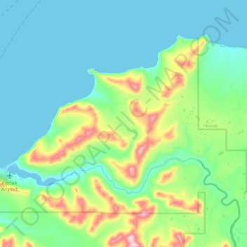
Name: Karluk topographic map, elevation, terrain.
Location: Karluk, Kodiak Island, Alaska, 99608, United States (57.54000 -154.52887 57.66375 -154.20966)
Average elevation: 413 ft
Minimum elevation: 0 ft
Maximum elevation: 2,041 ft
Kodiak Island trails, hiking, mountain biking, running and outdoor activities
Make a donation
Gear up for your next adventure:
As an Amazon Associate, this site earns from qualifying purchases at no extra cost to you.
Other topographic maps
Click on a map to view its topography, its elevation and its terrain.