
Bongabon topographic map
Click on the map to display elevation.
About this map
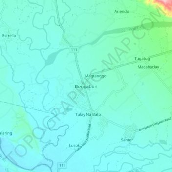
Name: Bongabon topographic map, elevation, terrain.
Location: Bongabon, Nueva Ecija, Central Luzon, 3128, Philippines (15.59216 121.10593 15.67216 121.18593)
Average elevation: 240 ft
Minimum elevation: 171 ft
Maximum elevation: 745 ft
Other topographic maps
Click on a map to view its topography, its elevation and its terrain.
Lupao
Lupao belongs to the first type of climate in the Philippines. This type of climate has two (2) pronounced seasons: dry from the month of November to April and Wet during the rest of the year. This type of climate is typically hot, humid and tropical and is generally affected by the neighboring topography and…
Average elevation: 574 ft
Talavera
The municipality's terrain is relatively flat, with slope ranging from 0 to 3%. Due to the flat topography, the land is suited for agricultural, commercial or industrial development. It is bordered by Cabanatuan, Llanera, Muñoz, Aliaga, General Mamerto Natividad, Santo Domingo and San Jose.
Average elevation: 161 ft
San Jose
The city of San Jose lies at 15° 47' North, 120° 59' East in Central Luzon. The estimated elevation at these coordinates is approximately 109.9 meters or 360.4 feet above mean sea level.
Average elevation: 482 ft
Muñoz
It is situated 30 kilometres (19 mi) from Cabanatuan, 44 kilometres (27 mi) from Palayan, and 146 kilometres (91 mi) north of the capital Manila. Due to its rich topography and tropical climate, it is now home to agricultural research and technology centers, committed to the production of information and…
Average elevation: 236 ft
Licab
About 155 kilometres (96 mi) north of Metro Manila, Licab lies in one of the lowest portions of the province with an average elevation of 24 metres (79 ft), experiencing flooding in all but one of its 11 barangays during rainy season.
Average elevation: 72 ft
General Tinio
The western portion consists of generally level to rolling plains formed by fluvial deposition, while the eastern portion rises into hilly and mountainous terrain. Elevation ranges from approximately 30 meters above sea level in lowland areas to over 1,200 meters in upland barangays such as Pias.
Average elevation: 367 ft
Nueva Ecija Old Provincial Capitol Plaza
Philippines > Nueva Ecija > Cabanatuan > Isla
Average elevation: 112 ft
Pantabangan Dam
Philippines > Nueva Ecija > Pantabangan > Fatima
The dam is a 107 m (351 ft) tall and 1,615 m (5,299 ft) long embankment-type with 12,000,000 cu yd (9,174,658 m3) of homogeneous earth-fill and an impervious core. The crest of the dam is 12 m (39 ft) wide while the widest part of its base is 535 m (1,755 ft). The dam's crest sits at an elevation of 232 m (761…
Average elevation: 689 ft
Lupao
Lupao belongs to the first type of climate in the Philippines. This type of climate has two (2) pronounced seasons: dry from the month of November to April and Wet during the rest of the year. This type of climate is typically hot, humid and tropical and is generally affected by the neighboring topography and…
Average elevation: 574 ft
General Tinio
The western portion consists of generally level to rolling plains formed by fluvial deposition, while the eastern portion rises into hilly and mountainous terrain. Elevation ranges from approximately 30 meters above sea level in lowland areas to over 1,200 meters in upland barangays such as Pias.
Average elevation: 367 ft
Pantabangan Dam
Philippines > Nueva Ecija > Pantabangan > Fatima
The dam is a 107 m (351 ft) tall and 1,615 m (5,299 ft) long embankment-type with 12,000,000 cu yd (9,174,658 m3) of homogeneous earth-fill and an impervious core. The crest of the dam is 12 m (39 ft) wide while the widest part of its base is 535 m (1,755 ft). The dam's crest sits at an elevation of 232 m (761…
Average elevation: 689 ft
San Jose
The city of San Jose lies at 15° 47' North, 120° 59' East in Central Luzon. The estimated elevation at these coordinates is approximately 109.9 meters or 360.4 feet above mean sea level. The city has two pronounced seasons, rainy season from the months of May to November and the dry season in the remaining…
Average elevation: 482 ft
Muñoz
Muñoz is situated 30 kilometres (19 mi) from Cabanatuan, 44 kilometres (27 mi) from Palayan, and 146 kilometres (91 mi) north of the capital Manila. Due to its rich topography and tropical climate, it is now home to agricultural research and technology centers, committed to the production of information and…
Average elevation: 236 ft
Licab
About 155 kilometres (96 mi) north of Metro Manila, Licab lies in one of the lowest portions of the province with an average elevation of 24 metres (79 ft), experiencing flooding in all but one of its 11 barangays during rainy season.
Average elevation: 72 ft
Muñoz
Muñoz is situated 30 kilometres (19 mi) from Cabanatuan, 44 kilometres (27 mi) from Palayan, and 146 kilometres (91 mi) north of the capital Manila. Due to its rich topography and tropical climate, it is now home to agricultural research and technology centers, committed to the production of information and…
Average elevation: 236 ft
San Jose
The city of San Jose lies at 15° 47' North, 120° 59' East in Central Luzon. The estimated elevation at these coordinates is approximately 109.9 meters or 360.4 feet above mean sea level. The city has two pronounced seasons, rainy season from the months of May to November and the dry season in the remaining…
Average elevation: 482 ft