
Thank you for supporting this site ❤️
Make a donation
Make a donation
Gear up for your next adventure:
As an Amazon Associate, this site earns from qualifying purchases at no extra cost to you.
Oxford topographic map
Click on the map to display elevation.
Thank you for supporting this site ❤️
Make a donation
Make a donation
Gear up for your next adventure:
As an Amazon Associate, this site earns from qualifying purchases at no extra cost to you.
About this map
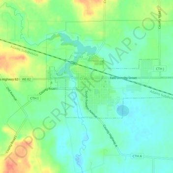
Name: Oxford topographic map, elevation, terrain.
Location: Oxford, Marquette County, Wisconsin, United States (43.77388 -89.58229 43.78578 -89.53722)
Average elevation: 876 ft
Minimum elevation: 823 ft
Maximum elevation: 971 ft
Thank you for supporting this site ❤️
Make a donation
Make a donation
Gear up for your next adventure:
As an Amazon Associate, this site earns from qualifying purchases at no extra cost to you.
Other topographic maps
Click on a map to view its topography, its elevation and its terrain.
Observatory Hill State Natural Area
United States > Wisconsin > Marquette County
Average elevation: 860 ft