
Thank you for supporting this site ❤️
Make a donation
Make a donation
Gear up for your next adventure:
As an Amazon Associate, this site earns from qualifying purchases at no extra cost to you.
Hittnau topographic map
Click on the map to display elevation.
Thank you for supporting this site ❤️
Make a donation
Make a donation
Gear up for your next adventure:
As an Amazon Associate, this site earns from qualifying purchases at no extra cost to you.
About this map
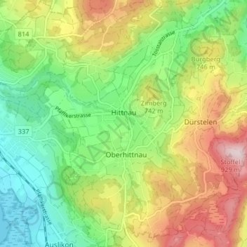
Name: Hittnau topographic map, elevation, terrain.
Location: Hittnau, Bezirk Pfäffikon, Zurich, 8335, Switzerland (47.34421 8.80209 47.38825 8.85721)
Average elevation: 2,270 ft
Minimum elevation: 1,755 ft
Maximum elevation: 3,028 ft
Thank you for supporting this site ❤️
Make a donation
Make a donation
Gear up for your next adventure:
As an Amazon Associate, this site earns from qualifying purchases at no extra cost to you.