Geolocate

2 topographic map

Click on the map to display elevation.

About this map

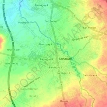
Name: 2 topographic map, elevation, terrain.

Location: 2, Tanauan, Batangas, Calabarzon, 4232, Philippines (14.06735 121.12828 14.10735 121.16828)

Average elevation: 505 ft

Minimum elevation: 410 ft

Maximum elevation: 600 ft

Other topographic maps

Click on a map to view its topography, its elevation and its terrain.

Maria Paz

Philippines > Batangas > Tanauan

Average elevation: 210 ft

Barangay 3

Philippines > Batangas > Tanauan > Hidalgo

Average elevation: 518 ft

Barangay 5

Philippines > Batangas > Tanauan > Hidalgo

Average elevation: 505 ft

Suplang

Philippines > Batangas > Tanauan

Average elevation: 810 ft

Barangay 5

Philippines > Batangas > Tanauan > Hidalgo

Average elevation: 505 ft

Gear up for your next adventure:

💧Water Filtration Bottles - Safely drink from streams and lakes while exploring
🪶Camping Sleeping Pad - Comfortable sleeping pad for backpacking
🧥Waterproof Jacket for Hiking - Breathable and rugged rain jacket for outdoor excursions
🏕️Tent Footprint - Protect your tent base from wear
🗺️NatGeo Topo Maps - High-quality waterproof printed topographic maps of US Parks

As an Amazon Associate, this site earns from qualifying purchases at no extra cost to you.