Geolocate

Ashingdon topographic map

Click on the map to display elevation.

About this map

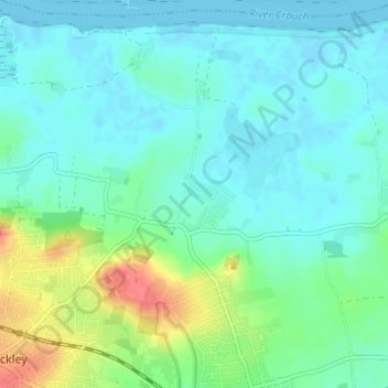
Name: Ashingdon topographic map, elevation, terrain.

Location: Ashingdon, Rochford, Essex, England, United Kingdom (51.59824 0.65490 51.63672 0.71249)

Average elevation: 46 ft

Minimum elevation: -7 ft

Maximum elevation: 187 ft

Other topographic maps

Click on a map to view its topography, its elevation and its terrain.

Sutton

United Kingdom > England > Essex > Rochford

Average elevation: 36 ft

Hawkwell

United Kingdom > England > Essex > Rochford

Average elevation: 105 ft

Stroud Green

United Kingdom > England > Essex > Rochford

Average elevation: 72 ft

Rawreth

United Kingdom > England > Essex > Rochford

Average elevation: 43 ft

Great Stambridge

United Kingdom > England > Essex > Rochford

Average elevation: 26 ft

Foulness Island

United Kingdom > England > Essex > Rochford

Average elevation: 3 ft

Potash Woods

United Kingdom > England > Essex > Rochford > Hawkwell

Average elevation: 95 ft

Battlesbridge

United Kingdom > England > Essex > Rochford > Battlesbridge

Average elevation: 49 ft

Gear up for your next adventure:

🦺Reflective Outdoor Gear - Safety gear for low‑light conditions
🦶Hiking Gaiters - Keep debris and water out of your boots
🛏️Cold Weather Sleeping Bag - Warm sleeping bag for cold conditions
📦Gear Storage Bags - Organize and protect outdoor equipment
🥇GPS Hiking Watch - Multi‑sport GPS watch with navigation and trail tracking

As an Amazon Associate, this site earns from qualifying purchases at no extra cost to you.