
Make a donation
Gear up for your next adventure:
As an Amazon Associate, this site earns from qualifying purchases at no extra cost to you.
Secaucus topographic map
Click on the map to display elevation.
Make a donation
Gear up for your next adventure:
As an Amazon Associate, this site earns from qualifying purchases at no extra cost to you.
About this map
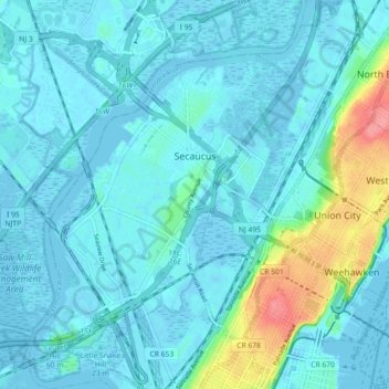
Name: Secaucus topographic map, elevation, terrain.
Location: Secaucus, Hudson County, New Jersey, United States (40.74905 -74.09496 40.80770 -74.03302)
Average elevation: 43 ft
Minimum elevation: -16 ft
Maximum elevation: 262 ft
Hudson County trails, hiking, mountain biking, running and outdoor activities
Make a donation
Gear up for your next adventure:
As an Amazon Associate, this site earns from qualifying purchases at no extra cost to you.
Other topographic maps
Click on a map to view its topography, its elevation and its terrain.
Croxton
United States > New Jersey > Hudson County > Jersey City > Journal Square
Average elevation: 52 ft
Make a donation
Gear up for your next adventure:
As an Amazon Associate, this site earns from qualifying purchases at no extra cost to you.
North Hudson Park
United States > New Jersey > Hudson County > North Bergen > Hudson Heights
Average elevation: 135 ft
Ellis Island
United States > New Jersey > Hudson County > Jersey City > Communipaw
The first floor contained detention rooms, social service offices, and waiting rooms on its west wing, a use that remained relatively unchanged. The central space was initially a baggage room until 1907, but was subsequently subdivided and later re-combined into a single records room. The first floor's east…
Average elevation: 3 ft
Make a donation
Gear up for your next adventure:
As an Amazon Associate, this site earns from qualifying purchases at no extra cost to you.
Bergen Square
United States > New Jersey > Hudson County > Jersey City > Journal Square
Average elevation: 43 ft
Marion
United States > New Jersey > Hudson County > Jersey City > Journal Square
Average elevation: 39 ft
Make a donation
Gear up for your next adventure:
As an Amazon Associate, this site earns from qualifying purchases at no extra cost to you.
Make a donation
Gear up for your next adventure:
As an Amazon Associate, this site earns from qualifying purchases at no extra cost to you.
Croxton
United States > New Jersey > Hudson County > Jersey City > Journal Square
Average elevation: 52 ft
Hudson River Waterfront
United States > New Jersey > Hudson County > Jersey City
Average elevation: 7 ft
North End Business District
United States > New Jersey > Hudson County > Secaucus
Average elevation: 13 ft
Bergen Square
United States > New Jersey > Hudson County > Jersey City > Journal Square
Average elevation: 43 ft
Make a donation
Gear up for your next adventure:
As an Amazon Associate, this site earns from qualifying purchases at no extra cost to you.