
Make a donation
Gear up for your next adventure:
As an Amazon Associate, this site earns from qualifying purchases at no extra cost to you.
Währing topographic map
Click on the map to display elevation.
Make a donation
Gear up for your next adventure:
As an Amazon Associate, this site earns from qualifying purchases at no extra cost to you.
About this map
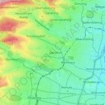
Name: Währing topographic map, elevation, terrain.
Location: Währing, Vienne, 1180, Autriche (48.21725 16.28237 48.25098 16.35377)
Average elevation: 810 ft
Minimum elevation: 554 ft
Maximum elevation: 1,407 ft
Make a donation
Gear up for your next adventure:
As an Amazon Associate, this site earns from qualifying purchases at no extra cost to you.
Other topographic maps
Click on a map to view its topography, its elevation and its terrain.
Kahlenberg
Le Kahlenberg (prononciation allemande : [ˈkaːlənˌbɛʁk]) est une colline du Kahlengebirge située à Döbling, le 19e arrondissement de Vienne, en Autriche. Le sommet, qui culmine à 484 m d'altitude, est l'un des points de vue les plus connus sur la capitale. Lors du second siège de Vienne en 1683, il…
Average elevation: 1,079 ft