
Make a donation
Gear up for your next adventure:
As an Amazon Associate, this site earns from qualifying purchases at no extra cost to you.
Hörbolz topographic map
Click on the map to display elevation.
Make a donation
Gear up for your next adventure:
As an Amazon Associate, this site earns from qualifying purchases at no extra cost to you.
Hörbolz
Stadtteile: Aeschach | Bad Schachen | Degelstein | Hochbuch | Hoyren | Insel | Oberreutin | Reutin | Rickenbach | Schönau | Wannental | Zech Pfarrdörfer: Oberreitnau | Unterreitnau Dörfer: Bechtersweiler | Eggatsweiler | Heimesreutin | Höhenreute | Hörbolz | Motzach | Niederhaus | Oberhochsteg | Oberrengersweiler | Rengersweiler | Rickatshofen | Streitelsfingen Weiler: Dachsberg | Dürren | Giebelbach | Goldschmidsmühle | Greit | Hangnach | Hörbolzmühle | Humbertsweiler | Lattenweiler | Paradies | Sauters | Sulzenberg | Waltersberg Einöden: Bahnholz | Gitzenweiler | Grünlach | Hugelitz | Schönbühl | Sulzenmoos | Unterwaltersberg | Wiesfleck
Make a donation
Gear up for your next adventure:
As an Amazon Associate, this site earns from qualifying purchases at no extra cost to you.
About this map
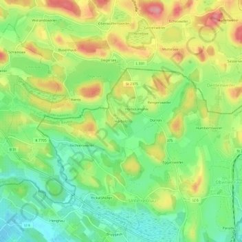
Name: Hörbolz topographic map, elevation, terrain.
Average elevation: 1,572 ft
Minimum elevation: 1,407 ft
Maximum elevation: 1,785 ft
Make a donation
Gear up for your next adventure:
As an Amazon Associate, this site earns from qualifying purchases at no extra cost to you.
Other topographic maps
Click on a map to view its topography, its elevation and its terrain.
BSB-Hafen Lindau (Bodensee)
Deutschland > Bayern > Landkreis Lindau > Lindau (Bodensee)
Average elevation: 1,296 ft
88131
Deutschland > Bayern > Landkreis Lindau > Lindau (Bodensee) > Schönau
Average elevation: 1,463 ft