
Manching topographic map
Click on the map to display elevation.
About this map
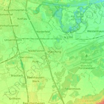
Name: Manching topographic map, elevation, terrain.
Average elevation: 1,204 ft
Minimum elevation: 1,148 ft
Maximum elevation: 1,302 ft
Other topographic maps
Click on a map to view its topography, its elevation and its terrain.
Scheuerhof
Germany > Bavaria > Landkreis Pfaffenhofen an der Ilm > Geisenfeld > Parleiten
Average elevation: 1,280 ft
Gosseltshausen
Germany > Bavaria > Landkreis Pfaffenhofen an der Ilm > Wolnzach
Average elevation: 1,401 ft
Oberdünzing
Germany > Bavaria > Landkreis Pfaffenhofen an der Ilm > Vohburg an der Donau
Average elevation: 1,214 ft