
Thank you for supporting this site ❤️
Make a donation
Make a donation
Gear up for your next adventure:
As an Amazon Associate, this site earns from qualifying purchases at no extra cost to you.
Holyhead topographic map
Click on the map to display elevation.
Thank you for supporting this site ❤️
Make a donation
Make a donation
Gear up for your next adventure:
As an Amazon Associate, this site earns from qualifying purchases at no extra cost to you.
About this map
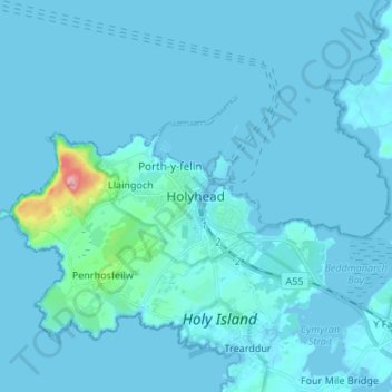
Name: Holyhead topographic map, elevation, terrain.
Location: Holyhead, Isle of Anglesey, Wales, LL65 1UN, United Kingdom (53.27067 -4.67310 53.35067 -4.59310)
Average elevation: 33 ft
Minimum elevation: -3 ft
Maximum elevation: 712 ft
Thank you for supporting this site ❤️
Make a donation
Make a donation
Gear up for your next adventure:
As an Amazon Associate, this site earns from qualifying purchases at no extra cost to you.
Other topographic maps
Click on a map to view its topography, its elevation and its terrain.
Llanfairpwllgwyngyll
United Kingdom > Wales > Isle of Anglesey > Llanfairpwllgwyngyll
Average elevation: 138 ft