
Make a donation
Gear up for your next adventure:
As an Amazon Associate, this site earns from qualifying purchases at no extra cost to you.
Hirschhausen topographic map
Click on the map to display elevation.
Make a donation
Gear up for your next adventure:
As an Amazon Associate, this site earns from qualifying purchases at no extra cost to you.
Hirschhausen
Das Dorf liegt, von Wald umgeben, im nordöstlichen Taunus (östlicher Hintertaunus), 5,4 km nordöstlich der Weilburger Kernstadt. Durch den Ort führt die Kreisstraße 412. Der Ort selbst liegt auf 248 bis 298 Metern Höhe, während das Gelände im Nordosten der Gemarkung auf bis zu 321 Meter ansteigt.
Make a donation
Gear up for your next adventure:
As an Amazon Associate, this site earns from qualifying purchases at no extra cost to you.
About this map
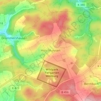
Name: Hirschhausen topographic map, elevation, terrain.
Average elevation: 902 ft
Minimum elevation: 610 ft
Maximum elevation: 1,152 ft
Make a donation
Gear up for your next adventure:
As an Amazon Associate, this site earns from qualifying purchases at no extra cost to you.