
Thank you for supporting this site ❤️
Make a donation
Make a donation
Gear up for your next adventure:
As an Amazon Associate, this site earns from qualifying purchases at no extra cost to you.
Garin topographic map
Click on the map to display elevation.
Thank you for supporting this site ❤️
Make a donation
Make a donation
Gear up for your next adventure:
As an Amazon Associate, this site earns from qualifying purchases at no extra cost to you.
About this map
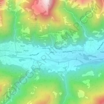
Name: Garin topographic map, elevation, terrain.
Location: Garin, Villar Pellice, Turin, Piémont, Italie (44.78731 7.12354 44.82731 7.16354)
Average elevation: 3,173 ft
Minimum elevation: 1,995 ft
Maximum elevation: 5,735 ft
Thank you for supporting this site ❤️
Make a donation
Make a donation
Gear up for your next adventure:
As an Amazon Associate, this site earns from qualifying purchases at no extra cost to you.
Other topographic maps
Click on a map to view its topography, its elevation and its terrain.
Vallée de Pellice
Italie > Piémont > Turin > Villar Pellice
Dans le val Pellice, des refuges alpins permettent des randonnées en altitude.
Average elevation: 4,364 ft