
Make a donation
Gear up for your next adventure:
As an Amazon Associate, this site earns from qualifying purchases at no extra cost to you.
Torre del Bierzo topographic map
Click on the map to display elevation.
Make a donation
Gear up for your next adventure:
As an Amazon Associate, this site earns from qualifying purchases at no extra cost to you.
Torre del Bierzo
De spoorlijn van Ponferrada naar León maakt bij het dorp La Granja een lus van bijna zes kilometer en kruist daarbij zichzelf. Het hoogteverschil bij de kruising is ongeveer 100 meter.
Make a donation
Gear up for your next adventure:
As an Amazon Associate, this site earns from qualifying purchases at no extra cost to you.
About this map
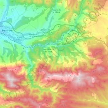
Name: Torre del Bierzo topographic map, elevation, terrain.
Location: Torre del Bierzo, El Bierzo, León, Castilië en León, Spanje (42.50191 -6.40016 42.65957 -6.22142)
Average elevation: 3,409 ft
Minimum elevation: 2,057 ft
Maximum elevation: 5,121 ft
Make a donation
Gear up for your next adventure:
As an Amazon Associate, this site earns from qualifying purchases at no extra cost to you.
Other topographic maps
Click on a map to view its topography, its elevation and its terrain.
El Puente de Domingo Flórez / A Ponte
Spanje > Castilië en León > El Bierzo > Puente de Domingo Flórez
Average elevation: 1,729 ft
Make a donation
Gear up for your next adventure:
As an Amazon Associate, this site earns from qualifying purchases at no extra cost to you.
Ponferrada
Spanje > Castilië en León > El Bierzo > Ponferrada > Ponferrada
Average elevation: 1,916 ft
Las Médulas
Spanje > Castilië en León > El Bierzo > Carucedo > Las Médulas
Average elevation: 2,451 ft
San Fiz do Seo
Spanje > Castilië en León > El Bierzo > Trabadelo > San Fiz do Seo
Average elevation: 2,566 ft