
Thank you for supporting this site ❤️
Make a donation
Make a donation
Gear up for your next adventure:
As an Amazon Associate, this site earns from qualifying purchases at no extra cost to you.
Rauna topographic map
Click on the map to display elevation.
Thank you for supporting this site ❤️
Make a donation
Make a donation
Gear up for your next adventure:
As an Amazon Associate, this site earns from qualifying purchases at no extra cost to you.
About this map
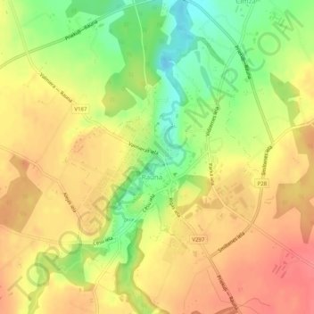
Name: Rauna topographic map, elevation, terrain.
Location: Rauna, Raunas pagasts, Smiltenes novads, Vidzeme, Latvia (57.32366 25.59281 57.34421 25.62454)
Average elevation: 427 ft
Minimum elevation: 292 ft
Maximum elevation: 518 ft
Thank you for supporting this site ❤️
Make a donation
Make a donation
Gear up for your next adventure:
As an Amazon Associate, this site earns from qualifying purchases at no extra cost to you.
Other topographic maps
Click on a map to view its topography, its elevation and its terrain.
Bormaņi
Latvia > Vidzeme > Smiltenes novads > Raunas pagasts > Cimza > Bormaņi
Average elevation: 456 ft