
Make a donation
Gear up for your next adventure:
As an Amazon Associate, this site earns from qualifying purchases at no extra cost to you.
Isla Otoque topographic map
Click on the map to display elevation.
Make a donation
Gear up for your next adventure:
As an Amazon Associate, this site earns from qualifying purchases at no extra cost to you.
Isla Otoque
La isla de Otoque está al norte de la isla Boná, a 1 milla de distancia. La forma de la isla es irregular, con un diámetro aproximado de 1 milla. La isla tiene dos cerros, ambos de elevación ligeramente menor al punto más alto de la isla Boná.
Make a donation
Gear up for your next adventure:
As an Amazon Associate, this site earns from qualifying purchases at no extra cost to you.
About this map
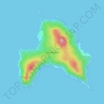
Name: Isla Otoque topographic map, elevation, terrain.
Location: Isla Otoque, Distrito Taboga, Panamá (8.59140 -79.61176 8.61258 -79.59180)
Average elevation: 62 ft
Minimum elevation: -13 ft
Maximum elevation: 551 ft
Make a donation
Gear up for your next adventure:
As an Amazon Associate, this site earns from qualifying purchases at no extra cost to you.