
Make a donation
Gear up for your next adventure:
As an Amazon Associate, this site earns from qualifying purchases at no extra cost to you.
Strongoli topographic map
Click on the map to display elevation.
Make a donation
Gear up for your next adventure:
As an Amazon Associate, this site earns from qualifying purchases at no extra cost to you.
About this map
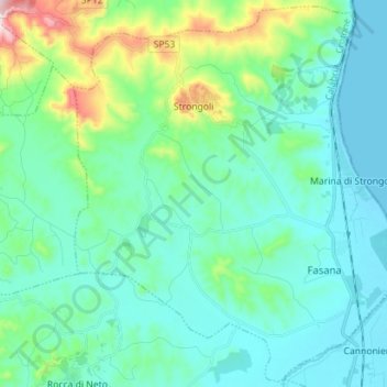
Name: Strongoli topographic map, elevation, terrain.
Location: Strongoli, Crotone, Calabria, Italia (39.18616 17.00807 39.29214 17.14893)
Average elevation: 308 ft
Minimum elevation: 0 ft
Maximum elevation: 1,657 ft
Make a donation
Gear up for your next adventure:
As an Amazon Associate, this site earns from qualifying purchases at no extra cost to you.
Other topographic maps
Click on a map to view its topography, its elevation and its terrain.
Make a donation
Gear up for your next adventure:
As an Amazon Associate, this site earns from qualifying purchases at no extra cost to you.
Capo Piccolo
Italia > Calabria > Crotone > Isola di Capo Rizzuto > Sant'Antonio
Average elevation: 49 ft