
Make a donation
Gear up for your next adventure:
As an Amazon Associate, this site earns from qualifying purchases at no extra cost to you.
Mkuyuni topographic map
Click on the map to display elevation.
Make a donation
Gear up for your next adventure:
As an Amazon Associate, this site earns from qualifying purchases at no extra cost to you.
About this map
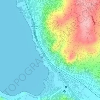
Name: Mkuyuni topographic map, elevation, terrain.
Location: Mkuyuni, Nyamagana, Mwanza Region, Lake Zone, Tanzania (-2.56224 32.90417 -2.54297 32.92889)
Average elevation: 3,862 ft
Minimum elevation: 3,714 ft
Maximum elevation: 4,242 ft
Make a donation
Gear up for your next adventure:
As an Amazon Associate, this site earns from qualifying purchases at no extra cost to you.
Other topographic maps
Click on a map to view its topography, its elevation and its terrain.
Make a donation
Gear up for your next adventure:
As an Amazon Associate, this site earns from qualifying purchases at no extra cost to you.
Mwanza
Mwanza features a tropical savanna climate under the Köppen climate classification. Temperatures are relatively consistent throughout the course of the year, tempered by the city's altitude. Thus, the climate is not quite as hot as one might expect, given the city's location near the equator. Average…
Average elevation: 3,865 ft
Make a donation
Gear up for your next adventure:
As an Amazon Associate, this site earns from qualifying purchases at no extra cost to you.