
Make a donation
Gear up for your next adventure:
As an Amazon Associate, this site earns from qualifying purchases at no extra cost to you.
Estreito topographic map
Click on the map to display elevation.
Make a donation
Gear up for your next adventure:
As an Amazon Associate, this site earns from qualifying purchases at no extra cost to you.
About this map
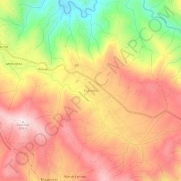
Name: Estreito topographic map, elevation, terrain.
Location: Estreito, Oleiros, Castelo Branco, Portugal (39.93356 -7.83099 39.97356 -7.79099)
Average elevation: 2,156 ft
Minimum elevation: 1,204 ft
Maximum elevation: 2,812 ft
Make a donation
Gear up for your next adventure:
As an Amazon Associate, this site earns from qualifying purchases at no extra cost to you.
Other topographic maps
Click on a map to view its topography, its elevation and its terrain.
Ribeira de Cambas - Ribeira das Casas da Zebreira
Portugal > Castelo Branco > Oleiros
Average elevation: 1,900 ft
Make a donation
Gear up for your next adventure:
As an Amazon Associate, this site earns from qualifying purchases at no extra cost to you.
Isna
Portugal > Castelo Branco > Oleiros
A altitude média é aproximadamente 730 m, situa-se num vale de altitude ao qual o Cabeço Rainho é sobranceiro. A distância à sede do município, a vila de Oleiros, é de 14 km, com Sobreira Formosa a 12 km e Castelo Branco a 61 km.
Average elevation: 2,375 ft